
Inertial Labs launches visual-aided inertial navigation system
Inertial Labs, a VIAVI Solutions company, has announced the launch of a visual-aided inertial navigation system (VINS) that enables aircraft to maintain accurate flightpaths when no reliable GPS/GNSS signal is available.
The launch comes as the U.S. Department of Transportation (DOT) is reporting an increase in GPS signal jamming and spoofing in North America and in much of Western Europe. This affects commercial and military operations, with up to 700 global GPS spoofing and jamming incidences taking place daily. Events are particularly concentrated around war zones, with Lithuanian airspace alone recording over 800 cases of GPS interference during the last three months of 2024. Also affected are the communications and emergency service sectors, which also rely on precise timing and geolocation.
VINS enables Unmanned Aerial Vehicles (UAVs) to accomplish very long-range missions in the most GNSS-challenged environments. VINS uses a robust 3D vision-based positioning software from Maxar Raptor to estimate a vehicle’s absolute 3D position by applying Perspective and Point (PnP) principles to compare patterns captured from an onboard camera (day or infrared) with satellite imagery-derived Maxar Precision3D maps.
In GNSS-denied environments VINS has demonstrated the ability to maintain its flight path with horizontal position to within 35 m, vertical position to within 5 m and desired velocity to within 0.9 m/s of true location and velocity. It is also able to hold heading to within 1 degree and pitch/roll to within 0.1 degree. With GNSS enabled, it is able to maintain a horizontal position of 1 m, a sub-2 m vertical position and a velocity of 0.03 m/s, with a heading accuracy of 0.1 degrees and a pitch/roll of within 0.03 degrees.
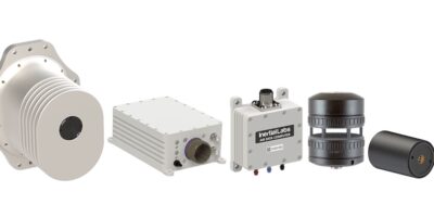
The system is designed for operation at low altitudes. The modular system incorporates processing and sensor modules, a GNSS or CRPA antenna plus an air-data computer and digital windspeed sensor for operation with both fixed-wing and multi-rotor UAVs.
VINS can optionally be equipped with a commercial off-the-shelf (COTS) radio to be used for data as well as to provide absolute position in GPS-denied environments. An Iridium LEO GNSS and M-code/SAASM GNSS receiver is also available.